
The island is part of the mainland surrounded by reservoirs. If we look at the globe, then all land can be called a huge island, right? And when we compare the largest island – Greenland, with the smallest continent – Australia, three Greenland could fit in the land of kangaroos.
Apart from similar discussions today, there are maps with the most important islands and island archipelagos. Due to a large amount of material, I divided the topic into two parts: in the first, I will show the islands around Eurasia, and in the other continents.
The maps come from Wikipedia and Google Maps. And as usual, please take a correction for minor inaccuracies in their graphic processing. At the archipelagos, in parentheses, I have included all the main islands. If you still need a higher resolution map, open the image in a separate tab.
I marked the islands or archipelagos with green, the larger islands of the archipelagos with orange, and the yellow groups of islands that are nearby so that the signatures are unambiguous.
Europe
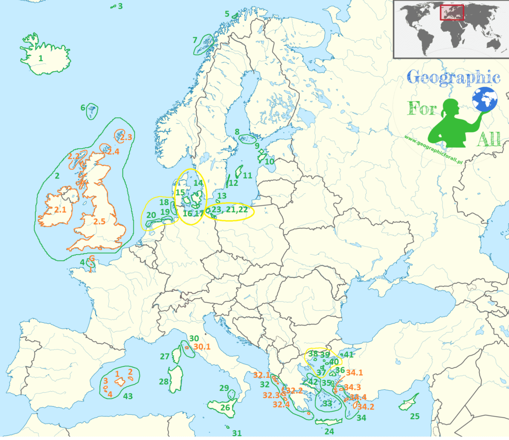
- Iceland
- British Isles (also: Isles of Scilly, Anglesey, Man, Arran, Wight, Bute)
- Ireland
- Hebrides
- Shetland Islands
- Orkney Islands
- United Kingdom
- Jan Mayen
- Channel Islands (Guernsey and Jersey)
- Soroya
- Faroe Islands
- Lofoten
- Åland Islands
- Hiiumaa
- Saaremaa
- Gotland
- Oland
- Bornholm
- Zealand
- Fiona
- Lolland
- Falster
- North Frisian Islands
- East Frisian Islands
- West Frisian Islands
- Usedom
- Wolin
- Rugen
- Crete
- Cyprus
- Sicilia
- Corsica
- Sardinia
- Aeolian Islands
- Tuscan Islands (Giglio, Capraia, Montecristo)
- Elba
- Malta
- Ionian Islands (Lefkada, Kithira, Skorpios, Kalamos, Paxos)
- Corfu
- Ithaca
- Kefalonia
- Zakynthos
- Cyclades (Kea, Andros, Tinos, Siros, Paros, Naxos, Amorgos, Santorini)
- Sporades (Kalimnos, Tilos, Saria, Karpathos, Kasos)
- Ikaria
- Rhodes
- Samos
- Cos
- Chios
- Lesbos
- Limnos
- Thasos
- Samothrace
- Imroz
- Marmara
- Northern Sporades (Skiros, Skopelos, Alonisos and several smaller ones)
- Balearic Islands
- Mallorca
- Minorca
- Ibiza
- Formentera
Azja
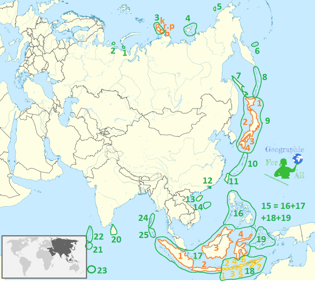
- Wajgacz * contractually belongs to Europe
- Kolguyev Island
- Northern Land (Komsomolec [k], October Revolution Island [rp], Bolshevik [b])
- New Siberian Islands (Anjou Islands, New Siberia, Kotlielnyj, Lachiv Islands)
- Wrangel Island
- Commander Islands
- Sakhalin
- Kurile
- Japanese Islands
- Hokkaido
- Honshu
- Shikoku
- Kyushu
- Riukiu Islands (largest Okinawa, Sakishima Islands, Amami Islands, Tokara Islands)
- Taiwan
- Hong Kong
- Hainan
- Paracel Islands
- Malay Archipelago (Small and Great Sunda Islands, Moluki, Philippines)
- Philippines (Luzon, Mindanao, Palawan, Sulu Archipelago)
- Great Sunda Islands
- Sumatra
- Java
- Borneo
- Sulawesi
- Small Sunda Islands
- Bali
- Lombok
- Sumbawa
- Komodo
- Sumba
- Flores
- Timor
- Maluku
- Ceylon
- Maldives
- Laccadive Islands
- Chagos Islands
- Andaman Islands
- Nicobar Islands
0 Comments for “Physical map of the world – islands part 1: Europe and Asia”