Urbanization in more and less developed countries is different. Let’s check how much and what the phenomena accompany it.
How are cities usually created?
The settlement is preferably located, for example, on a trade route, and even better if it is the seat of local or regional authorities. It is attractive for local people to migrate. Many inhabitants mean a large market, so food processing and the textile industry are developing.
The industry needs energy and machinery, which is why mineral extraction (if any) and heavy industry are developed. On the one hand, this is another magnet for immigration of new residents, and on the other, the need to fill new jobs. The city is developing with residential and commercial buildings.
This is obviously a big shortcut and simplification, and the growth of cities depends on many factors.
Urbanization in more and less developed countries
The basis of the LDCs* economy is agriculture, and thus much fewer citizens work in industry and services than in MDCs*. Depending on the percentage of the urban population, we can talk about:
- countries in the stage of urbanization, where cities are not large and migrations are slow. E.g. Ethiopia, Laos, Niger, Bangladesh
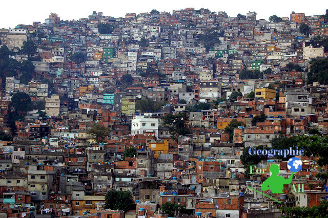
- countries in the stage of suburbanization, in which the influx of people from the overcrowded village is large and much faster than the needs of developing cities. This creates neighbourhoods of the poor – slums (Brazilian favelas) e.g. in Jakarta, Mumbai, Calcutta, and Manila. E.g. Philippines, Nigeria, India, Indonesia, Egypt
- countries where demographic overurbanization has occurred, particularly in South and Central America. They are characterized by a high percentage of urban population (70-90%). However, the reasons for this are mixed. Industry and services offer jobs (more than in countries from item 1), but a poor village encourages migration to cities (less than in countries from item 2). Sometimes Latin American countries fall under 2.1.
Urbanization in more developed countries
Cities in MDCs have a balanced proportion of the urban population – residents cover the demand for employees. Prosperity rather than poverty is usually a problem. People spend commuting time in traffic jams, industrial plants pollute the environment, etc. Therefore, in MDCs we are talking more about deglomeration, i.e. planned measures that limit the growth of agglomeration. Such activities may include moving existing factories outside the city, i.e. active deglomeration, usually expensive and inefficient (e.g. Warsaw, Budapest). On the other hand, passive deglomeration is better. For example encouraging the relocation of plants and the creation of new ones outside the city. Authorities have financial (high contra relief taxes, high land prices in the city) and administrative tools (prohibitions related to environmental protection or tourism). An example of successful deglomeration is London, where the process was based on the idea of „garden cities”.
*LDCs = least developed countries
*MDCs = more developed countries
0 Comments for “Urbanization in more and less developed countries – phenomena”