
Earth’s core is very hot, you don’t need to convince anyone. What happens to this heat and energy before they reach the surface? This is what lithosphere tectonics theory is about, among other things. To begin with, I will explain the basic issues and later explain how scientists came up with this.
Convection and subduction – tectonics in a nutshell
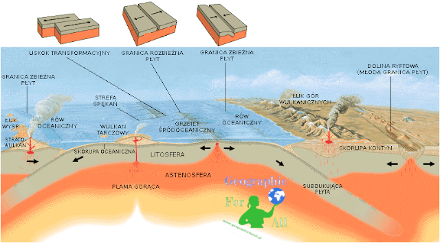
The heat rises up – whether it is warm air or hot magma. This phenomenon is called convection. The further away from the planet’s core, the more it cools down. In some places magma breaks the lithosphere layer and gets to the surface. Sudden hypothermia causes the magma to freeze. However, more portions are still coming in from below, so young rocks are pushed aside and create new fragments of the ocean floor or relief.
Everything is balanced in nature. If the seabed arrives in one place, it should decrease somewhere else. This happens in subduction zones. Individual plates overlap, pushing adjacent ones down. Higher temperatures prevail there and the rocks are melted into magma again.
The main assumptions of the plate tectonics theory are:
- the lithosphere consists of plates – Pacific, Nazca, North American, South American, Eurasian, African, Indo-Australian, Antarctic, and several smaller ones e.g. Arab, Indian, Caribbean, Filipino, Coconut
- lithosphere plates are rigid blocks sliding over the plastic asthenosphere due to the drift of continents, they are divided into oceanic and oceanic-continental
- lithosphere plates are built around mid-oceanic ridges and destroyed in subduction zones
- continental fragments of continental oceanic plates are not destroyed because they are lighter
- continental blocks may have Atlantic-type edges when inside the plate (Antarctica) or Andean type when they are in contact with another plate (Andes, Himalayas)
![Płyty litosfery, By Adi4000 (Own work) [Public domain], via Wikimedia Commons; Lithosphere Discs, By Adi4000 (Own work) [Public domain], via Wikimedia Commons](https://geographicforall.com/wp-content/uploads//2017/01/Plyty_tektoniczne.svg_.png)
By-products of tectonics
Due to the continuous circulation of magma and rocks, new forms are created on the surface of the lithosphere. They are made of basalt magma, the main building blocks of the ocean floor and the bottom of lands, or andesite, which is the basis of the continental crust.
- rift, rift valley – an axial fissure in the seabed where basalt magma is extracted
- Mid-oceanic ridge – the ridge surrounding the rift on both sides. They are rocks that are young and have not fallen lower like the material of the abyssal plains.
- hot spots – clusters of magma occurring deeper than foci forming rifts. They can form near rift valleys (Iceland, Red Sea), and away from them (Hawaii). They do not change their position, so the seabed sliding over them gives space to create new islands.
- shield basalt volcanoes , forming island archipelagos (Hawaii)
- island arches, marginal seas and oceanic trenches – formed in the subduction zones of two oceanic plates.
- young coastal mountains – just like island arches are formed in subduction zones, but ocean plate with continental.
- earthquakes, volcanic eruptions – the lithosphere is a huge mass of rocks, so with any collisions or frictions between the plates, there are shocks and interruption of the earth’s crust.
- transformational faults – formed at the junction of two plates that drift at different speeds, e.g. the San Andreas fault in California
The hypothesis of ocean floor growth and lithospheric plates
The fact that the bottom of the oceans is expanding has been discovered relatively recently. In the 1950s, it was noted that inland rift valleys (e.g. in Africa) the points move away from each other. Similar studies were conducted by Marie Tharp and Bruce Heezen for oceanic valleys. They found that the earth’s crust had such tears because the interior of the Earth was expanding. It was a somewhat catastrophic theory.
Other conclusions were reached by Robert S. Dietz and Harry H. Hess in the early 1960s. They measured the temperature of the rocks and their age. In the rift valleys, they were the warmest and the youngest, which confirmed that new magma rocks were born there. Another determinant of ocean floor growth, which F. Vine and D. Matthews , was the magnetization of the rocks parallel to the rift. In the first period, the rocks formed were in accordance with the magnetism of the planet. After the inversion of the magnetic field, the new rocks turned toward the new pole. Thus, the ocean floor is covered with stripes compatible with and not compatible with the current magnetism of the Earth.
0 Comments for “Tectonics of lithosphere plates”