In Physical map of the world – islands part 1 we covered the islands from Europe and Asia. This time we will look at the islands around other continents.
Africa
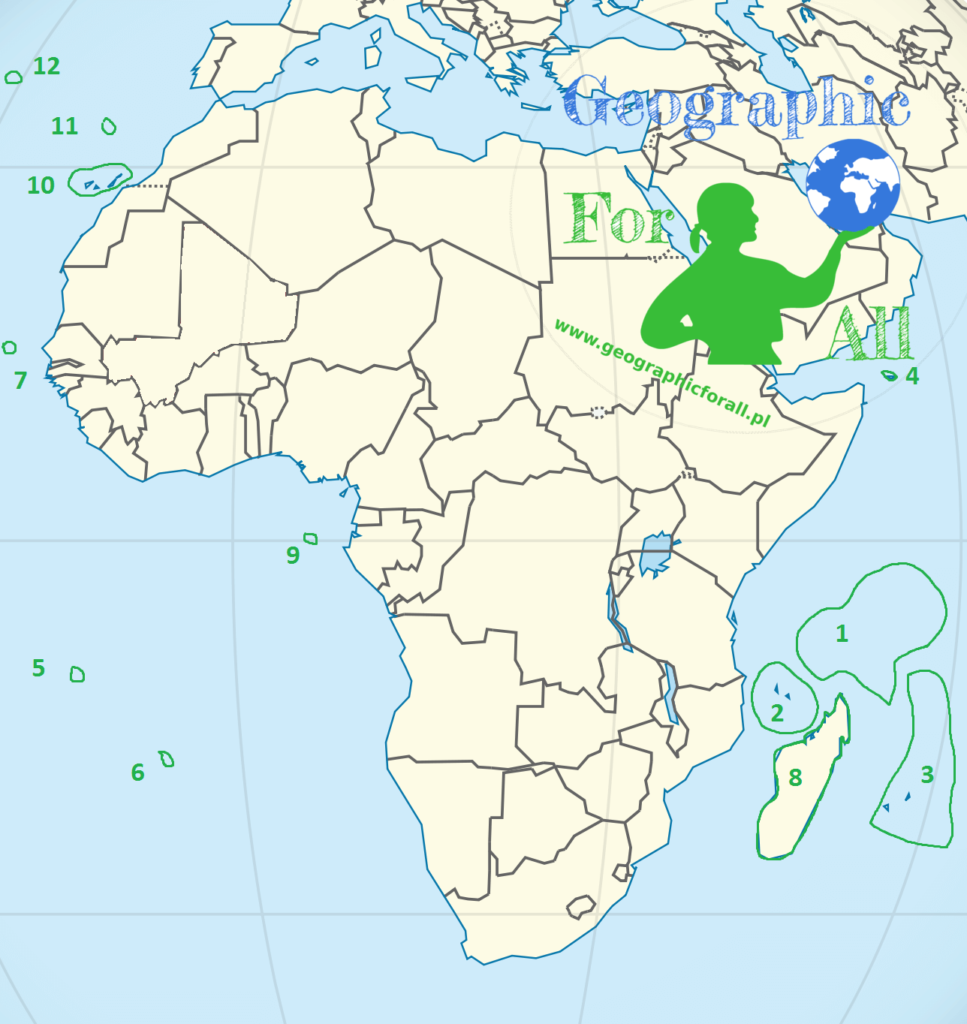
- Seychelles
- Comoros
- Maskarena (Mauritius, Reunion, Rodriques)
- Sokorta
- Ascension Island
- Saint Helena Island
- Cape Verde Islands
- Madagascar
- Saint Thomas Island and Prince’s Island
- Canary Islands (Palma, Hierro, Gomera, Tenerife, Gran Canaria, Fuerteventura, Lanzarote, Graciosa, Alegranza)
- Madeira
- Azores
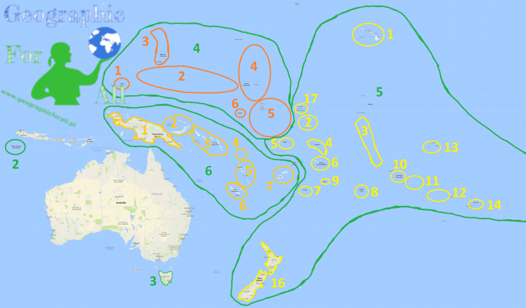
Australia and Oceania

- Coconut Islands
- Christmas Island
- Tasmania
- Micronesia
- Palau
- Carolina
- Northern Mariana Islands
- Marshall Islands
- Gilbert Islands
- Nauru
- Polynesia
- Hawaii
- Phoenix Islands
- Line
- Tokelau
- Tuvalu / Lagoon Islands
- Samoa
- Tonga
- Cook Islands
- Niue
- Society Islands (including Tahiti and Bora Bora)
- Tuamotu
- Gambiera Islands
- Awning
- Pitcairn
- Easter Island
- New Zealand
- Howland (it was supposed to be a stop here Amelia Earhart )
- Melanesia
- New Guinea
- Bismarck Archipelago (including New Ireland, New Britain, Admiralty Islands)
- Solomon Islands
- St. Cruz
- New Hebrides
- New Caledonia
- Fiji
North America
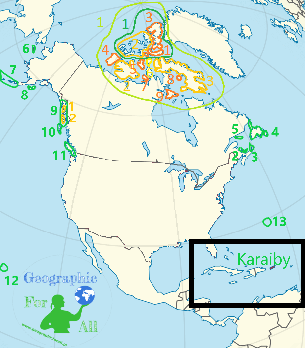
- Arctic archipelago
- Isle of Queen Elizabeth (since 1953) / Isle of Parry
- Parry Islands (Cornwallis, Prince Patrick Island and others)
- Devon
- Sverdrup Islands (Axel Heiberg, Ellef Ringnes, Amund Ringnes and others)
- Ellesmere Island
- Parry Islands (Cornwallis, Prince Patrick Island and others)
- Victoria Island
- Baffin land
- Banks Island
- Prince of Wales Island
- Somerset
- King William Island
- Prince Charles Island
- Southampton
- Isle of Queen Elizabeth (since 1953) / Isle of Parry
- Prince Edward Island
- Cape Breton
- Newfoundland
- Anticosti
- St. Lawrence Island
- Aleutian Islands
- Kodjak
- Alexander Archipelago (among others, Cziczagowska Island, Revilla Gigedo, Kurpejanowa, Kościuszki and others)
- Admiralty Island
- Prince of Wales Island
- Isle of Queen Charlotte (including Graham Island, Moresby)
- Vancouver
- Hawaii
- Bermudas
Caribbean
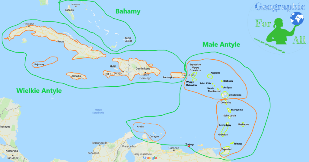
- Bahamas
- Greater Antilles
- Cuba
- Dominican Republic (on Hispaniola)
- Haiti (on Hispaniola)
- Jamaica
- Puerto Rico
- Cayman Islands
- Lesser Antilles
- Windward Islands
- Virgin Islands
- British Virgin Islands
- Anguilla
- Saint Kitts
- Nevis
- Barbuda
- Antigua
- Montserrat
- Guadeloupe
- Windward Islands
- Dominica
- Martinique
- Saint Lucia
- Grenadines (including Saint Vincent, Grenada)
- Barbados
- Trinidad
- Tobago
- Netherlands Antilles (Curacao and Aruba)
- Tortuga
- Windward Islands
South America

- Galapagos Islands
- Juan Fernandez Islands
- Tierra del Fuego
- Falkland Islands / Malvinas
- San Felix
- Coconut Island
- Rocas and Fernando de Noronha
- South Georgia
0 Comments for “Physical map of the world – islands part 2: Africa, Australia and Americas”