Ocean water movements – tides

tides


Warning: file_exists(): open_basedir restriction in effect. File(/home/augxdkk/www/geographicforall.pl/wp-content/uploads/geoip/GeoLite2-Country.mmdb) is not within the allowed path(s): (/home/klient.dhosting.pl/biurorock/geographicforall.com/:/home/klient.dhosting.pl/biurorock/.tmp/:/demonek/www/public/bledy.demonek.com/:/usr/local/lsws/share/autoindex:/usr/local/php/:/dev/urandom:/opt/alt/php82/usr/share/pear/:/opt/alt/php82/usr/share/php:/opt/alt/php82/) in /home/klient.dhosting.pl/biurorock/geographicforall.com/public_html/wp-content/plugins/geoip-detect/data-sources/manual.php on line 233

Warning: file_exists(): open_basedir restriction in effect. File(/home/augxdkk/www/geographicforall.pl/wp-content/uploads/geoip/GeoLite2-Country.mmdb) is not within the allowed path(s): (/home/klient.dhosting.pl/biurorock/geographicforall.com/:/home/klient.dhosting.pl/biurorock/.tmp/:/demonek/www/public/bledy.demonek.com/:/usr/local/lsws/share/autoindex:/usr/local/php/:/dev/urandom:/opt/alt/php82/usr/share/pear/:/opt/alt/php82/usr/share/php:/opt/alt/php82/) in /home/klient.dhosting.pl/biurorock/geographicforall.com/public_html/wp-content/plugins/geoip-detect/data-sources/manual.php on line 233

Warning: file_exists(): open_basedir restriction in effect. File(/home/augxdkk/www/geographicforall.pl/wp-content/uploads/geoip/GeoLite2-Country.mmdb) is not within the allowed path(s): (/home/klient.dhosting.pl/biurorock/geographicforall.com/:/home/klient.dhosting.pl/biurorock/.tmp/:/demonek/www/public/bledy.demonek.com/:/usr/local/lsws/share/autoindex:/usr/local/php/:/dev/urandom:/opt/alt/php82/usr/share/pear/:/opt/alt/php82/usr/share/php:/opt/alt/php82/) in /home/klient.dhosting.pl/biurorock/geographicforall.com/public_html/wp-content/plugins/geoip-detect/data-sources/manual.php on line 233

Warning: file_exists(): open_basedir restriction in effect. File(/home/augxdkk/www/geographicforall.pl/wp-content/uploads/geoip/GeoLite2-Country.mmdb) is not within the allowed path(s): (/home/klient.dhosting.pl/biurorock/geographicforall.com/:/home/klient.dhosting.pl/biurorock/.tmp/:/demonek/www/public/bledy.demonek.com/:/usr/local/lsws/share/autoindex:/usr/local/php/:/dev/urandom:/opt/alt/php82/usr/share/pear/:/opt/alt/php82/usr/share/php:/opt/alt/php82/) in /home/klient.dhosting.pl/biurorock/geographicforall.com/public_html/wp-content/plugins/geoip-detect/data-sources/manual.php on line 233

Warning: file_exists(): open_basedir restriction in effect. File(/home/augxdkk/www/geographicforall.pl/wp-content/uploads/geoip/GeoLite2-Country.mmdb) is not within the allowed path(s): (/home/klient.dhosting.pl/biurorock/geographicforall.com/:/home/klient.dhosting.pl/biurorock/.tmp/:/demonek/www/public/bledy.demonek.com/:/usr/local/lsws/share/autoindex:/usr/local/php/:/dev/urandom:/opt/alt/php82/usr/share/pear/:/opt/alt/php82/usr/share/php:/opt/alt/php82/) in /home/klient.dhosting.pl/biurorock/geographicforall.com/public_html/wp-content/plugins/geoip-detect/data-sources/manual.php on line 233

As I wrote earlier, the water in the oceans is not motionless. Today we will deal with a slightly more astronomical aspect of these movements.

Tides

Tides is otherwise repeated, regular displacement of masses within celestial bodies arising as a result of external factors. On our planet, we observe them mainly in the hydrosphere and atmosphere, and the gravity of the sun is the external factor and the moon and the Earth’s rotation.

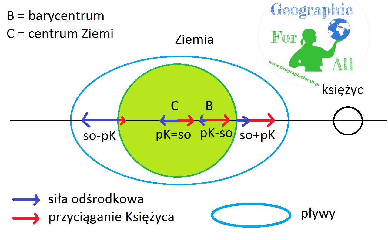
The moon attracts water, so there is more of it from its side, and the centrifugal force is minimal and supports tides. The next point on the Moon-Earth axis is the barycenter, where the centrifugal force begins to work with the inverse vector, but is still small. In the centre of the planet, both forces balance each other. On the opposite side of the Earth, the moon’s attraction is small, but the outward centrifugal force increases, which causes a tide on the other side of the planet. From here the waters form an “egg”. The highest tide is recorded every 12 hours and 27 minutes on individual meridians. Why not every 24 hours? Because the Moon is once on one side and once on the other side of the Earth, but there is also the other tide on the opposite side 🙂

Pływy morskie z rozkładem sił Tides with the distribution of forces
Tides with the distribution of forces

Tide types

As I mentioned, the sun also influences the tides, although it is much smaller because it is further away. The gravity of the Sun and Moon can be consistent, then the tides are larger, or quarrel with each other, then the tides are smaller.

Pływy morskie - syzygijne i kwadraturowe By MesserWoland (own work created in Inkscape) [GFDL (http://www.gnu.org/copyleft/fdl.html), CC-BY-SA-3.0 (http://creativecommons.org/licenses/by-sa/3.0/) or CC BY-SA 2.5-2.0-1.0 (http://creativecommons.org/licenses/by-sa/2.5-2.0-1.0)], via Wikimedia Commons Tides of the sea - spring tide and neap tide, By MesserWoland (own work created in Inkscape) [GFDL (http://www.gnu.org/copyleft/fdl.html), CC-BY-SA-3.0 (http://creativecommons.org/licenses/by-sa/3.0/) or CC BY-SA 2.5-2.0-1.0 (http://creativecommons.org/licenses/by-sa/ 2.5-2.0-1.0)], via Wikimedia Commons
Tides of the sea – spring tide and neap tide, By MesserWoland (own work created in Inkscape) [GFDL (http://www.gnu.org/copyleft/fdl.html), CC-BY-SA-3.0 (http://creativecommons.org/licenses/by-sa/3.0/) or CC BY-SA 2.5-2.0-1.0 (http://creativecommons.org/licenses/by-sa/ 2.5-2.0-1.0)], via Wikimedia Commons
In the figure above both these situations are marked. The number (4) indicates the attraction of the star and (5) the moon. In situation (A), the yellow Sun (1) aligns with Earth (2) and the Moon (3). You can see immediately that the tides are larger, about 3 times. The effect is best seen when the Earth is closest to the star and the Moon is closest to the Earth. We then call them spring tides, occurring during the new moon and the full moon.
Figure (B) shows the neap tides encountered during the first and last quarters. The waters have incompatible attraction forces, so the tides are no longer that high.

Impact of tides on geography and man

The height of the tide also depends on the type of coast, latitude, and the shape of the seabed. Therefore, the waves range from a centimetre in open waters to 18 m. They have multiple environmental impacts.

  1. Vertical movements
    1. tidal power plants particularly desirable in river mouths and bays, where the highest amplitudes are found, e.g. Fundy Bay in Canada, the mouths of the Yangtze River, the Amazon River and St. Lawrence, English Channel.
    2. collecting seafood – shrimp clams, etc. With a large area of the coast exposed at low tide, you can collect marine flora and fauna without the need for traditional fishing
  2. Horizontal movements, the so-called tidal currents
    1. backwater of large rivers, e.g. Amazons, about 100 km deep – saltwater species occur in rivers
    2. keeping large amounts of freshwater at the point of its mouth into the ocean
Rate this post

This post is also available in: polski


Warning: file_exists(): open_basedir restriction in effect. File(/home/augxdkk/www/geographicforall.pl/wp-content/uploads/geoip/GeoLite2-Country.mmdb) is not within the allowed path(s): (/home/klient.dhosting.pl/biurorock/geographicforall.com/:/home/klient.dhosting.pl/biurorock/.tmp/:/demonek/www/public/bledy.demonek.com/:/usr/local/lsws/share/autoindex:/usr/local/php/:/dev/urandom:/opt/alt/php82/usr/share/pear/:/opt/alt/php82/usr/share/php:/opt/alt/php82/) in /home/klient.dhosting.pl/biurorock/geographicforall.com/public_html/wp-content/plugins/geoip-detect/data-sources/manual.php on line 233
>

Leave a Reply

Your email address will not be published. Required fields are marked *

This site uses Akismet to reduce spam. Learn how your comment data is processed.