History of urbanization development – part 1


Warning: file_exists(): open_basedir restriction in effect. File(/home/augxdkk/www/geographicforall.pl/wp-content/uploads/geoip/GeoLite2-Country.mmdb) is not within the allowed path(s): (/home/klient.dhosting.pl/biurorock/geographicforall.com/:/home/klient.dhosting.pl/biurorock/.tmp/:/demonek/www/public/bledy.demonek.com/:/usr/local/lsws/share/autoindex:/usr/local/php/:/dev/urandom:/opt/alt/php82/usr/share/pear/:/opt/alt/php82/usr/share/php:/opt/alt/php82/) in /home/klient.dhosting.pl/biurorock/geographicforall.com/public_html/wp-content/plugins/geoip-detect/data-sources/manual.php on line 233

Warning: file_exists(): open_basedir restriction in effect. File(/home/augxdkk/www/geographicforall.pl/wp-content/uploads/geoip/GeoLite2-Country.mmdb) is not within the allowed path(s): (/home/klient.dhosting.pl/biurorock/geographicforall.com/:/home/klient.dhosting.pl/biurorock/.tmp/:/demonek/www/public/bledy.demonek.com/:/usr/local/lsws/share/autoindex:/usr/local/php/:/dev/urandom:/opt/alt/php82/usr/share/pear/:/opt/alt/php82/usr/share/php:/opt/alt/php82/) in /home/klient.dhosting.pl/biurorock/geographicforall.com/public_html/wp-content/plugins/geoip-detect/data-sources/manual.php on line 233

Warning: file_exists(): open_basedir restriction in effect. File(/home/augxdkk/www/geographicforall.pl/wp-content/uploads/geoip/GeoLite2-Country.mmdb) is not within the allowed path(s): (/home/klient.dhosting.pl/biurorock/geographicforall.com/:/home/klient.dhosting.pl/biurorock/.tmp/:/demonek/www/public/bledy.demonek.com/:/usr/local/lsws/share/autoindex:/usr/local/php/:/dev/urandom:/opt/alt/php82/usr/share/pear/:/opt/alt/php82/usr/share/php:/opt/alt/php82/) in /home/klient.dhosting.pl/biurorock/geographicforall.com/public_html/wp-content/plugins/geoip-detect/data-sources/manual.php on line 233

Warning: file_exists(): open_basedir restriction in effect. File(/home/augxdkk/www/geographicforall.pl/wp-content/uploads/geoip/GeoLite2-Country.mmdb) is not within the allowed path(s): (/home/klient.dhosting.pl/biurorock/geographicforall.com/:/home/klient.dhosting.pl/biurorock/.tmp/:/demonek/www/public/bledy.demonek.com/:/usr/local/lsws/share/autoindex:/usr/local/php/:/dev/urandom:/opt/alt/php82/usr/share/pear/:/opt/alt/php82/usr/share/php:/opt/alt/php82/) in /home/klient.dhosting.pl/biurorock/geographicforall.com/public_html/wp-content/plugins/geoip-detect/data-sources/manual.php on line 233

Warning: file_exists(): open_basedir restriction in effect. File(/home/augxdkk/www/geographicforall.pl/wp-content/uploads/geoip/GeoLite2-Country.mmdb) is not within the allowed path(s): (/home/klient.dhosting.pl/biurorock/geographicforall.com/:/home/klient.dhosting.pl/biurorock/.tmp/:/demonek/www/public/bledy.demonek.com/:/usr/local/lsws/share/autoindex:/usr/local/php/:/dev/urandom:/opt/alt/php82/usr/share/pear/:/opt/alt/php82/usr/share/php:/opt/alt/php82/) in /home/klient.dhosting.pl/biurorock/geographicforall.com/public_html/wp-content/plugins/geoip-detect/data-sources/manual.php on line 233

Warning: file_exists(): open_basedir restriction in effect. File(/home/augxdkk/www/geographicforall.pl/wp-content/uploads/geoip/GeoLite2-Country.mmdb) is not within the allowed path(s): (/home/klient.dhosting.pl/biurorock/geographicforall.com/:/home/klient.dhosting.pl/biurorock/.tmp/:/demonek/www/public/bledy.demonek.com/:/usr/local/lsws/share/autoindex:/usr/local/php/:/dev/urandom:/opt/alt/php82/usr/share/pear/:/opt/alt/php82/usr/share/php:/opt/alt/php82/) in /home/klient.dhosting.pl/biurorock/geographicforall.com/public_html/wp-content/plugins/geoip-detect/data-sources/manual.php on line 233

Warning: file_exists(): open_basedir restriction in effect. File(/home/augxdkk/www/geographicforall.pl/wp-content/uploads/geoip/GeoLite2-Country.mmdb) is not within the allowed path(s): (/home/klient.dhosting.pl/biurorock/geographicforall.com/:/home/klient.dhosting.pl/biurorock/.tmp/:/demonek/www/public/bledy.demonek.com/:/usr/local/lsws/share/autoindex:/usr/local/php/:/dev/urandom:/opt/alt/php82/usr/share/pear/:/opt/alt/php82/usr/share/php:/opt/alt/php82/) in /home/klient.dhosting.pl/biurorock/geographicforall.com/public_html/wp-content/plugins/geoip-detect/data-sources/manual.php on line 233

Warning: file_exists(): open_basedir restriction in effect. File(/home/augxdkk/www/geographicforall.pl/wp-content/uploads/geoip/GeoLite2-Country.mmdb) is not within the allowed path(s): (/home/klient.dhosting.pl/biurorock/geographicforall.com/:/home/klient.dhosting.pl/biurorock/.tmp/:/demonek/www/public/bledy.demonek.com/:/usr/local/lsws/share/autoindex:/usr/local/php/:/dev/urandom:/opt/alt/php82/usr/share/pear/:/opt/alt/php82/usr/share/php:/opt/alt/php82/) in /home/klient.dhosting.pl/biurorock/geographicforall.com/public_html/wp-content/plugins/geoip-detect/data-sources/manual.php on line 233

Warning: file_exists(): open_basedir restriction in effect. File(/home/augxdkk/www/geographicforall.pl/wp-content/uploads/geoip/GeoLite2-Country.mmdb) is not within the allowed path(s): (/home/klient.dhosting.pl/biurorock/geographicforall.com/:/home/klient.dhosting.pl/biurorock/.tmp/:/demonek/www/public/bledy.demonek.com/:/usr/local/lsws/share/autoindex:/usr/local/php/:/dev/urandom:/opt/alt/php82/usr/share/pear/:/opt/alt/php82/usr/share/php:/opt/alt/php82/) in /home/klient.dhosting.pl/biurorock/geographicforall.com/public_html/wp-content/plugins/geoip-detect/data-sources/manual.php on line 233

Urbanization goes back to antiquity because then the first urban centres began to appear. The term itself comes from Latin: urbs = city, urbanus = urban. Urbanization has also affected rural areas since the 19th century (e.g. cultivating the urban lifestyle in the countryside).
How dynamic and common this process is illustrated by statistics:

  • in 1800, only 14% of the population lived in cities,
  • in 1910 it was already 43.8%,
  • and in 2008 the whole 47%.

Ancient cities

The first center of urbanization arose around 4000 BC, downstream of the Tigris and Euphrates rivers (Mesopotamia).
The Sumerians were in the lead and two of their cities are worth mentioning. Nippur was the first city exceeding a million inhabitants. Ur had tens of thousands but crowded for about 90 ha. It consisted of an inner-city (so-called monastery district or temenos) with a ziggurat, where the king, aristocracy and priests resided. Outside its walls was an external city with two ports, having residential, commercial and craft functions.

The second centre was on the Mediterranean coast.
It's exactly about Phoenicians – excellent sailors, craftsmen, jewellers. Tyr was mainly known for the production of purple and was limited in area to an island located less than a kilometre from the mainland, which was of great defensive value. Other known Phoenician settlements are Akka, Sidon and Carthage. Most had commercial significance, were located on the coasts and had ports.

The third centre is the valley of the river Indus, where pre-Aryan peoples lived.
Examples of such cities are Harappa, Lothal, Mohenjo Daro. Interestingly, for the first time, grid-like street layout and sewerage was used.

The fourth centre included the Huang-he river basin, in 4,000 BC Chinese civilization reigned, and then, in 2 thousand BC – Huang he (urban) civilization.
The best example is the then capital Xi'an, occupying an 8.5 km long strip. In total, 11 avenues on the north-south axis and 14 east-west streets were marked out, which gave the skeleton to the grid-like street layout. The royal palace was located in the northern part, was directed to the south, fortified and closed to everyone. Public facilities were located outside the royal part.

The fifth centre is also a Mediterranean basin, but under Greek rule since the Great Colonization (VIII century BC).
Tribal communities began to crumble and cities expand to form new political structures – polis, or city-states. The Greeks paid less attention to adapting the buildings to natural conditions, as long as there was a hill. Each policy consisted of an inaccessible part located on a hill. Acropolis was the seat of gods, priests, housed the treasury and archives.

The rest, available to ordinary citizens, was distinguished by the hippameist street layout (grid-like, main wide streets, narrow side streets) with the central market square (agora). Interestingly, the agora had political and cultural functions – nearby, among others, buleurterion (seat of the city council) and theatre. Agora was also traded, although it was the second market that played a major role in the exchange. Every self-respecting city must also have a gymnasium connecting the school with the sports complex and baths. The Greeks also had running water supplied with enamelled pipes. The distinguishing feature of policies was the concentration of houses in the so-called urban blocks, i.e. 4 houses with an internal courtyard. The whole was surrounded by walls several meters long.

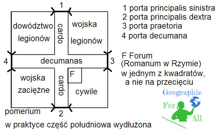
The sixth centre is, of course, ancient Rome. The Etruscans inhabited the Apennine Peninsula used to designate a pomerium. It was a sacred line, a city border, which was ploughed with the help of a white bull, and then walls were erected on its line. Breaks in the ploughed line marked places for gates. Then the Romans took advantage of the idea, but they went a step further because in addition to the outline they also marked two main streets – cardo (north-south line) and decumanus (east-west). And so on the basis of their military camps ( castrum / castra romana) later cities were created, e.g. Paris, Vienna, Cologne, Reims, Manchester, London. Like the inhabitants of other civilizations, the Romans took care of hygiene and owned aqueducts and sewage system.

Schemat i elementy castrum rzymskiego Diagram and elements of the Roman castrum
Diagram and elements of the Roman castrum

Medieval cities

European cities emerging in the Middle Ages usually had an irregular centripetal system. The focal point was the castle, palace or church, and other buildings departed from it.

In Poland, cities were formed in one of four ways:

  • expansion of the stronghold and borough
  • transformation of a market settlement, e.g. Opole
  • moved e.g. Kalisz
  • founded on a raw root (or “in cruda radice”)

The city is unequal to the city, but on the example of Krakow you can show several features that were often repeated:

  • the market square from which two perpendicular streets lead out
  • on or at the town hall, the tower on which the watch was kept
  • pillory, cloth hall, tenements of the richest townspeople on or near the market
  • religious buildings in neighbouring quarters or by the walls (town hall and churches, the higher the richer the city)
  • surrounded by walls, moats
  • no water supply, sewage system, wooden streets
  • no greenery apart from cemeteries

The end of the Middle Ages marked the fall of Constantinople – the best-fortified fortress-city of the time. Surrounded by three stripes of walls, it was conquered only twice.

The next part will describe Renaissance, Baroque and modern concepts, e.g. garden cities. To read here: History of urbanization development – part 2

Rate this post

This post is also available in: polski


Warning: file_exists(): open_basedir restriction in effect. File(/home/augxdkk/www/geographicforall.pl/wp-content/uploads/geoip/GeoLite2-Country.mmdb) is not within the allowed path(s): (/home/klient.dhosting.pl/biurorock/geographicforall.com/:/home/klient.dhosting.pl/biurorock/.tmp/:/demonek/www/public/bledy.demonek.com/:/usr/local/lsws/share/autoindex:/usr/local/php/:/dev/urandom:/opt/alt/php82/usr/share/pear/:/opt/alt/php82/usr/share/php:/opt/alt/php82/) in /home/klient.dhosting.pl/biurorock/geographicforall.com/public_html/wp-content/plugins/geoip-detect/data-sources/manual.php on line 233
>

Leave a Reply

Your email address will not be published. Required fields are marked *

This site uses Akismet to reduce spam. Learn how your comment data is processed.