In the „Temperature in the atmosphere” series, we have already talked about definitions and records, heat balance and albedo, as well as the greenhouse effect. However, not always the thermometer indication itself may be interesting, but also its changes. Not everywhere in the world the temperatures are the same, and their range can also be surprising. That is why we are talking about temperature amplitudes, i.e. fluctuations between extreme temperatures in the examined period. Daily and yearly temperature amplitudes are the most popular.
Daily air temperature amplitudes
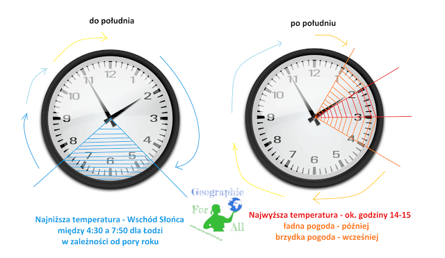
Whoever had the pleasure of standing guard on the morning or catching the train departing before dawn knows that the lowest air temperature is during sunrise. Then our star heats the air and the heat giving away soil. The warmest is around 14-15 hours. Depending on the weather a little later in nice weather, and sooner when there are clouds. Then it’s getting colder until the next sunrise.
Each day has the highest and lowest temperatures, which gives us daily amplitude. Its size depends on several factors:
- latitude
- season
- terrain
- cloudy
- continentalism (distance from water reservoirs, and consequently soil and air humidity).
Where can the highest daily amplitudes be found? In the near-tropical zone, the day should be summer and cloudless (high heating of the soil), far from large water reservoirs (soften the amplitude), in a non-covered valley. So it turns out that at night we will be coldest the most in … Sahara Desert 🙂 And this is not a joke – at day temperatures can reach 50-60 degrees, and at night they drop to zero.
Annual air temperature amplitudes
When we calculate the average daily temperature for a given location, we can translate it into a monthly and then an annual average. For example, the average temperature at the equator is 26.2 degrees, for latitude 30°- 20.4 (N) and 18.4 (S), for latitude 50°- 5.8, at the North Pole -22 and the South Pole -33, 1 degree Celsius. However, the average temperature really says little about local conditions. Which is why monthly averages form the basis for determining the annual amplitude. This, in turn, depends on:
- latitude – the higher the latitude, the greater the amplitude
- terrain relief
- continentalism
- altitude above sea level (the higher the smaller the difference).
The largest differences occur in northeastern Asia, North America and Antarctica. There is a large surface of dense lands at high latitudes – 30-60 degrees.
Average amplitudes, 10-30 degrees, occur over the Sahara Desert, South Africa, Australia, the rest of Asia and North America, and the southern part of South America.
The smallest differences are felt above the equator and oceans 3-7 degrees.
Looking at the temperatures of the warmest and coldest months for terrestrial and aquatic areas, it is worth paying attention to the fact that the oceans have about a month 'lag’ in relation to the lands. E.g. the warmest on land is July and on the ocean is August.
Types of annual course of air temperature according to Woś, 1996
There are 4 types of areas on Earth:
- equatorial – low annual amplitude, temperatures are mainly related to the season of the year – the warmest is at the equinox, the coldest in January and July => two minima + two maxima
- tropical – small and medium amplitudes of 5-20 degrees, larger above land, the warmest is before the monsoon, i.e. after the summer solstice, the coldest after winter => one maximum + one minimum
- moderate zone – maxima and minima similar to the tropical type, but the amplitude is higher – 15-40 degrees, higher above lands
- polar zone – the warmest is in the middle of the polar day, and the coldest in the middle of the polar night. The amplitudes are 20-50 degrees
Interesting facts
- The most extreme period for Polish temperatures was the 1920s. In 1921, the highest temperature readings in the whole country were recorded at the turn of July and August. It was over 38 degrees.
- In 1929, however, it chilled Poland the most. The Śląskie, Małopolskie and Podkarpackie voivodships were below minus 40 tonnes. Although the record was broken in 1940, but only in Siedlce City.
- Żywiec City boasts the highest long-term amplitude in this period – temperatures ranged from -40.6 to +38.
- The maximum long-term amplitude is 104 degrees C – from -71 to +33. It was measured in Russia, at Ojmiakon in Yakutia.
- The maximum daily amplitude is 55 degrees C – from -48 to +6.7. Comes from the USA, Browning.
0 Comments for “Atmospheric temperature – temperature amplitudes”