Altitudinal zonation in the mountains

piętra roślinne w górach z logo Altitudinal zonation in the mountains


Warning: file_exists(): open_basedir restriction in effect. File(/home/augxdkk/www/geographicforall.pl/wp-content/uploads/geoip/GeoLite2-Country.mmdb) is not within the allowed path(s): (/home/klient.dhosting.pl/biurorock/geographicforall.com/:/home/klient.dhosting.pl/biurorock/.tmp/:/demonek/www/public/bledy.demonek.com/:/usr/local/lsws/share/autoindex:/usr/local/php/:/dev/urandom:/opt/alt/php82/usr/share/pear/:/opt/alt/php82/usr/share/php:/opt/alt/php82/) in /home/klient.dhosting.pl/biurorock/geographicforall.com/public_html/wp-content/plugins/geoip-detect/data-sources/manual.php on line 233

Warning: file_exists(): open_basedir restriction in effect. File(/home/augxdkk/www/geographicforall.pl/wp-content/uploads/geoip/GeoLite2-Country.mmdb) is not within the allowed path(s): (/home/klient.dhosting.pl/biurorock/geographicforall.com/:/home/klient.dhosting.pl/biurorock/.tmp/:/demonek/www/public/bledy.demonek.com/:/usr/local/lsws/share/autoindex:/usr/local/php/:/dev/urandom:/opt/alt/php82/usr/share/pear/:/opt/alt/php82/usr/share/php:/opt/alt/php82/) in /home/klient.dhosting.pl/biurorock/geographicforall.com/public_html/wp-content/plugins/geoip-detect/data-sources/manual.php on line 233

Warning: file_exists(): open_basedir restriction in effect. File(/home/augxdkk/www/geographicforall.pl/wp-content/uploads/geoip/GeoLite2-Country.mmdb) is not within the allowed path(s): (/home/klient.dhosting.pl/biurorock/geographicforall.com/:/home/klient.dhosting.pl/biurorock/.tmp/:/demonek/www/public/bledy.demonek.com/:/usr/local/lsws/share/autoindex:/usr/local/php/:/dev/urandom:/opt/alt/php82/usr/share/pear/:/opt/alt/php82/usr/share/php:/opt/alt/php82/) in /home/klient.dhosting.pl/biurorock/geographicforall.com/public_html/wp-content/plugins/geoip-detect/data-sources/manual.php on line 233

Warning: file_exists(): open_basedir restriction in effect. File(/home/augxdkk/www/geographicforall.pl/wp-content/uploads/geoip/GeoLite2-Country.mmdb) is not within the allowed path(s): (/home/klient.dhosting.pl/biurorock/geographicforall.com/:/home/klient.dhosting.pl/biurorock/.tmp/:/demonek/www/public/bledy.demonek.com/:/usr/local/lsws/share/autoindex:/usr/local/php/:/dev/urandom:/opt/alt/php82/usr/share/pear/:/opt/alt/php82/usr/share/php:/opt/alt/php82/) in /home/klient.dhosting.pl/biurorock/geographicforall.com/public_html/wp-content/plugins/geoip-detect/data-sources/manual.php on line 233

Warning: file_exists(): open_basedir restriction in effect. File(/home/augxdkk/www/geographicforall.pl/wp-content/uploads/geoip/GeoLite2-Country.mmdb) is not within the allowed path(s): (/home/klient.dhosting.pl/biurorock/geographicforall.com/:/home/klient.dhosting.pl/biurorock/.tmp/:/demonek/www/public/bledy.demonek.com/:/usr/local/lsws/share/autoindex:/usr/local/php/:/dev/urandom:/opt/alt/php82/usr/share/pear/:/opt/alt/php82/usr/share/php:/opt/alt/php82/) in /home/klient.dhosting.pl/biurorock/geographicforall.com/public_html/wp-content/plugins/geoip-detect/data-sources/manual.php on line 233

Altitudinal zonation in the mountains is something obvious for everyone – foothil zone, alpine zone, snow zone. However, it is worth taking a closer look at these floors, as well as the differences in individual mountain chains.

General altitudinal zonation in the mountains
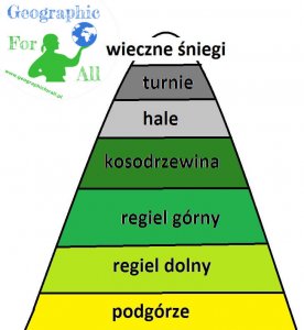
Piętra roślinności w górach schemat Altitudinal zonation in the mountains scheme
Altitudinal zonation in the mountains scheme
  • foothill zone
  • montane zone

alpine tree line

  • subalpine zone
  • low-alpine level
  • alpine zone

climatic snow line

  • snow zone / nival level

Specific altitudinal zonation in the mountains

Foothill zone is currently mainly used by humans, so it's difficult to talk about typical vegetation here. Nevertheless, once deciduous forests grew here.

In the Andes this zone is called tierra caliente * and the equatorial jungle grows there.

In lower part of montane zone there is a cool temperate climate and mixed or deciduous forest growing. There are brown earth type mountain. Although the growing season is not yet optimal, average temperatures are already higher than 0. In in tierra templada * you can find equatorial forest, but also coniferous species.

Upper part of montane zone is mainly coniferous, in Poland mainly spruce. The climate here is cool. In the Andes, zone tierra fria * is already really cold for tropics, but still “in the plus” – the alpine forest is growing here.

Mountain pine and green alder are found only in the subalpine zone in Central . In the Himalayas and the Alps, rhododendron grows in this sphere. A fairly compact network of plants protects the soil against erosion and stops smaller landslides and avalanches from higher zones.

Parano and puma are a cross between subalpine and alpine zone in . There is grassy vegetation, shrubs and shrubs, in the case of dry-loving and sun-loving puma.

Low alpine level, i.e. highland grasslands and meadows growing in cold temperate climates. There are annual plants. Landslides and avalanches often occur.

The alpine zone is a land of rocks. The vegetation includes mosses, lichens and some species of perennial flowers on soil scraps. Strong wind erosion, low temperatures. In the Andes, we will call this floor tierra helada *.

Snow zone, i.e. no vegetation, snow and rocks all year round. In South America, it is called tierra nevada *.
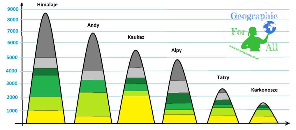
Floor heights

Comparison of plant floor heights in different mountain ranges, heights above sea level:

Zone
Tatra Mountains
Karkonosze
Andes
Himalayas
Alps
Caucasus Mountains
Foothill zone
Lower montane zone
650-1200
500-1000
600-2000
1000-2000
800-1000
2000-2600
Upper montane zone
1200-1500
1000-1250/1300
2200-3200
2000-3700
1000-1500
2600-3000
Subalpine zone
1500-1800
1250/1300-1450
3200-4000
3700-4200
1500-2200
3000-3500
Alpine zone
1800-2300
1450-1603
3200-4000
4200-5000
2200-3100
3500-4300
Snow zone
> 2300
> 4000
> 5000
> 3100
> 4300
Piętra roślinności w poszczególnych pasmach górskich, schemat poglądowy, skala zachowana w przybliżeniu Altitudinal zonation in individual mountain ranges, overview diagram, scale approximately
Altitudinal zonation in individual mountain ranges, overview diagram, scale approximately

*division by Humboldt

Rate this post

This post is also available in: polski Русский


Warning: file_exists(): open_basedir restriction in effect. File(/home/augxdkk/www/geographicforall.pl/wp-content/uploads/geoip/GeoLite2-Country.mmdb) is not within the allowed path(s): (/home/klient.dhosting.pl/biurorock/geographicforall.com/:/home/klient.dhosting.pl/biurorock/.tmp/:/demonek/www/public/bledy.demonek.com/:/usr/local/lsws/share/autoindex:/usr/local/php/:/dev/urandom:/opt/alt/php82/usr/share/pear/:/opt/alt/php82/usr/share/php:/opt/alt/php82/) in /home/klient.dhosting.pl/biurorock/geographicforall.com/public_html/wp-content/plugins/geoip-detect/data-sources/manual.php on line 233
>

Leave a Reply

Your email address will not be published. Required fields are marked *

This site uses Akismet to reduce spam. Learn how your comment data is processed.