Aeolian forms of terrain, i.e. wind carves – deserts and dunes

deserts and dunes


Warning: file_exists(): open_basedir restriction in effect. File(/home/augxdkk/www/geographicforall.pl/wp-content/uploads/geoip/GeoLite2-Country.mmdb) is not within the allowed path(s): (/home/klient.dhosting.pl/biurorock/geographicforall.com/:/home/klient.dhosting.pl/biurorock/.tmp/:/demonek/www/public/bledy.demonek.com/:/usr/local/lsws/share/autoindex:/usr/local/php/:/dev/urandom:/opt/alt/php82/usr/share/pear/:/opt/alt/php82/usr/share/php:/opt/alt/php82/) in /home/klient.dhosting.pl/biurorock/geographicforall.com/public_html/wp-content/plugins/geoip-detect/data-sources/manual.php on line 233

Warning: file_exists(): open_basedir restriction in effect. File(/home/augxdkk/www/geographicforall.pl/wp-content/uploads/geoip/GeoLite2-Country.mmdb) is not within the allowed path(s): (/home/klient.dhosting.pl/biurorock/geographicforall.com/:/home/klient.dhosting.pl/biurorock/.tmp/:/demonek/www/public/bledy.demonek.com/:/usr/local/lsws/share/autoindex:/usr/local/php/:/dev/urandom:/opt/alt/php82/usr/share/pear/:/opt/alt/php82/usr/share/php:/opt/alt/php82/) in /home/klient.dhosting.pl/biurorock/geographicforall.com/public_html/wp-content/plugins/geoip-detect/data-sources/manual.php on line 233

Warning: file_exists(): open_basedir restriction in effect. File(/home/augxdkk/www/geographicforall.pl/wp-content/uploads/geoip/GeoLite2-Country.mmdb) is not within the allowed path(s): (/home/klient.dhosting.pl/biurorock/geographicforall.com/:/home/klient.dhosting.pl/biurorock/.tmp/:/demonek/www/public/bledy.demonek.com/:/usr/local/lsws/share/autoindex:/usr/local/php/:/dev/urandom:/opt/alt/php82/usr/share/pear/:/opt/alt/php82/usr/share/php:/opt/alt/php82/) in /home/klient.dhosting.pl/biurorock/geographicforall.com/public_html/wp-content/plugins/geoip-detect/data-sources/manual.php on line 233

Warning: file_exists(): open_basedir restriction in effect. File(/home/augxdkk/www/geographicforall.pl/wp-content/uploads/geoip/GeoLite2-Country.mmdb) is not within the allowed path(s): (/home/klient.dhosting.pl/biurorock/geographicforall.com/:/home/klient.dhosting.pl/biurorock/.tmp/:/demonek/www/public/bledy.demonek.com/:/usr/local/lsws/share/autoindex:/usr/local/php/:/dev/urandom:/opt/alt/php82/usr/share/pear/:/opt/alt/php82/usr/share/php:/opt/alt/php82/) in /home/klient.dhosting.pl/biurorock/geographicforall.com/public_html/wp-content/plugins/geoip-detect/data-sources/manual.php on line 233

Warning: file_exists(): open_basedir restriction in effect. File(/home/augxdkk/www/geographicforall.pl/wp-content/uploads/geoip/GeoLite2-Country.mmdb) is not within the allowed path(s): (/home/klient.dhosting.pl/biurorock/geographicforall.com/:/home/klient.dhosting.pl/biurorock/.tmp/:/demonek/www/public/bledy.demonek.com/:/usr/local/lsws/share/autoindex:/usr/local/php/:/dev/urandom:/opt/alt/php82/usr/share/pear/:/opt/alt/php82/usr/share/php:/opt/alt/php82/) in /home/klient.dhosting.pl/biurorock/geographicforall.com/public_html/wp-content/plugins/geoip-detect/data-sources/manual.php on line 233

The terrain shaped by the wind is called aeolian. Deserts and dunes are the result of deflation (exhaust) and accumulation processes, but also corrosion (wind erosion, i.e. sand grinding with wind-blown sand) .

Types of deserts

Due to the material that mainly consists of the desert, we distinguish:

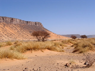
  • rocky deserts (hamada) e.g. part of the Sahara, in the Rocky Mountains
  • gravel deserts (serir in , gibber in Australia) e.g. part of the Sahara Desert, Gibson and Simpson Desert
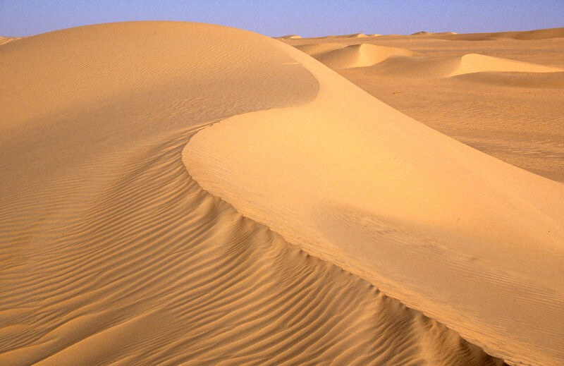
  • sandy deserts (erg) e.g. Atacama, Great Victoria Desert and Great Sandy Desert, Kyzył-kum and Kara-kum, Great Eastern West Erg,

The hamada landscape is solid rocks and smaller and larger boulders. Large temperature differences during good accelerate the crushing process. On its periphery, serir is often formed, because smaller crumbs are blown out from between large blocks and settle further.

Hamada w Algierii, Hamada in Algeria, autor: Florence Devouard, CC-BY-SA-3.0, via Wikimedia Commons
Hamada in Algeria, author: Florence Devouard, CC-BY-SA-3.0, via Wikimedia Commons
Serir, autor: Meteorite Recon, CC-BY-SA-3.0, via Wikimedia Commons
Serir, author: Meteorite Recon, CC-BY-SA-3.0, via Wikimedia Commons

Contrary to appearances, there are not so many sandy deserts in the world – ergs , well known from movies.

Erg, By Holger Reineccius CC-BY-SA-3.0, via Wikimedia Commons

A separate issue is loess, which arises from the extraction and accumulation of dust with a diameter less than 0.1 mm. Arises from dust extracted from deserts (continental) or post glacial areas (periglacial). I will discuss it in greater detail on the occasion of soils.

Types of dunes – basic

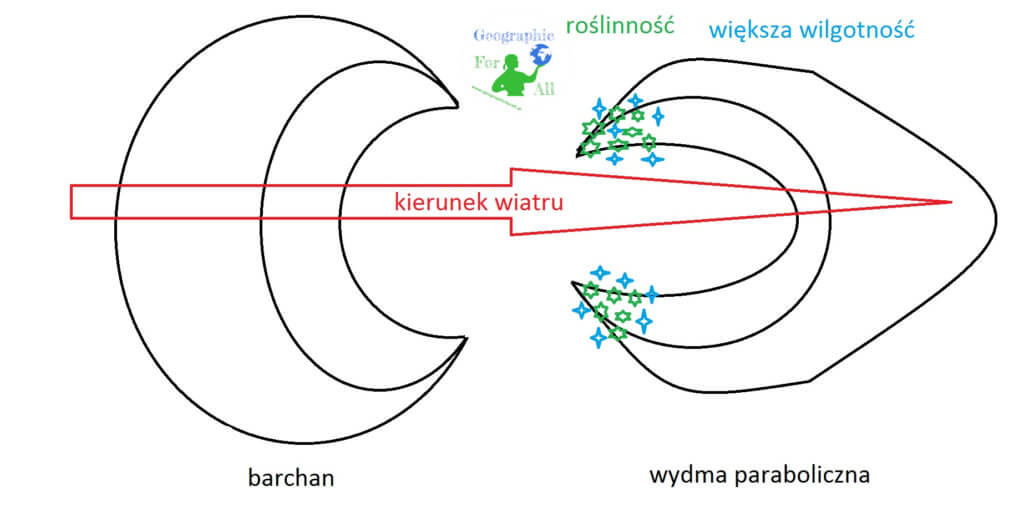
In order for a dune to be a dune, it should meet certain standards. And so the windward slope must not be more than 12 degrees, and leeward slope about 33 degrees. In profile, it looks a bit like a cross-section through an airplane wing. Their size varies – height up to 100 m, length from a few to several kilometers. Two main types of dunes are formed in sandy deserts – parabolic and sickle called barchans. The latter are only found on ergs.

Parabolic dunes point their arms toward the wind. Very often vegetation grows on the shoulders, or the water table is high enough to give sand a greater weight than dry on the forehead. This, in turn, causes the wind to move the grains that are the highest relative to the ground and most forward to the forefront. The arms move more slowly.

Crescent-shaped dunes, or barchans, have the opposite shape. They occur in drier regions, where humidity does not matter. The higher the hill, in this case the head of the dune, the harder it is to move it for the wind. The arms, where there is less sand, are lighter, so they spill faster and easier.

Barchan i wydma paraboliczna, Crescent-shaped dune (barchan) and parabolic dune
Crescent-shaped dune (barchan) and parabolic dune

Dunes types – other

In addition to the basic ones, we distinguish a few more varied shapes.

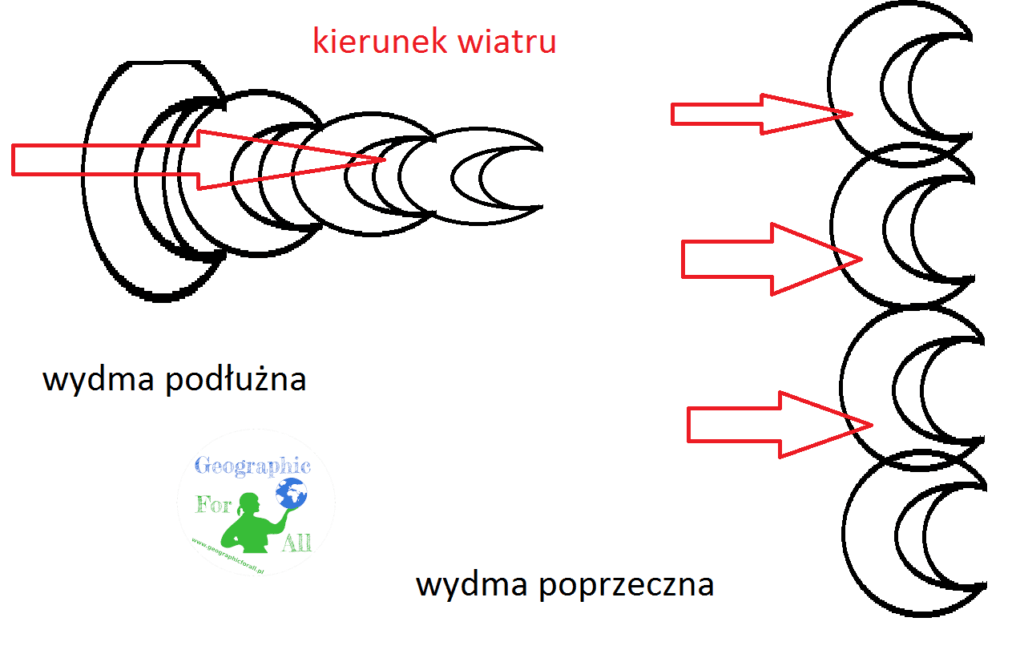
Transverse dunes are shafts perpendicular to the direction from which the wind blows. They are formed by joining the arms of neighboring dunes.

Longitudinal dunes need solid and strong winds to form, most often they are connected barchans spread one after the other on the wind line. They stretch for many kilometers.

Wydma podłużna i poprzeczna, Longitudinal dune and transverse dune
Longitudinal dune and transverse dune

Star dunes occur in areas where the wind is undecided which direction to blow or changes periodically. They resemble a star in shape.

Drassy is a kind of longitudinal dunes of impressive size – length 300-600 km, width up to 3 km and height up to 450 m. Their origin is not entirely clear.

Coastal dunes are made of sand from beaches. They are located parallel to the shoreline of water reservoirs. The largest are up to 100 m high. Some are called migratory dunes because they are still moving, expanding to further areas, e.g. in the Słowiński National Park.

Rate this post

This post is also available in: polski


Warning: file_exists(): open_basedir restriction in effect. File(/home/augxdkk/www/geographicforall.pl/wp-content/uploads/geoip/GeoLite2-Country.mmdb) is not within the allowed path(s): (/home/klient.dhosting.pl/biurorock/geographicforall.com/:/home/klient.dhosting.pl/biurorock/.tmp/:/demonek/www/public/bledy.demonek.com/:/usr/local/lsws/share/autoindex:/usr/local/php/:/dev/urandom:/opt/alt/php82/usr/share/pear/:/opt/alt/php82/usr/share/php:/opt/alt/php82/) in /home/klient.dhosting.pl/biurorock/geographicforall.com/public_html/wp-content/plugins/geoip-detect/data-sources/manual.php on line 233
>

Leave a Reply

Your email address will not be published. Required fields are marked *

This site uses Akismet to reduce spam. Learn how your comment data is processed.